For more pictures of our boat trip to the Gates of the
mountains click Gates
Friday, June 21, 2013
Gates of the Mountains
Merriweather Lewis named these rocky canyons the "Gates
of the Rocky Mountains", because, as you approach it on the river it looks
as though gates are opening. The only way
to see the effect is by boat.
Thursday, June 20, 2013
The Road to Montana
Beautiful, green, hilly, empty (nobody home) -- the road from Arco, ID to Helena, MT was another spectacularly scenic road. There were many farms, and then we went up into the mountains. Travelling north on I15, we noticed that exit zero was for Monida (name made up from Montana and Idaho). The town is right on the state line.
We crossed a mountain pass at 6000 feet and noticed a warning sign and a pullout for putting on chains (hopefully only in winter).
For more pictures, click Road to Montana
Craters of the Moon
Craters of the Moon, so named because that's what it looks like, is an area of volcanic rocks and craters. This area in Idaho is the most seismically active area in North America. This area has had an active volcanic eruption every 2000 years for the last 30,000 years. By the way, the last volcanic action was about 2100 years ago.
We took a scenic drive and took a few short hikes.
We were amazed at the abundant wildflowers, many just starting to sprout out of the lava rock. It was a stark contrast to see green plants with flowers growing out of the black volcanic rock. We imagine that in a few weeks the hills will be a riot of color.
We spent the next day waiting out a series of storm fronts that passed through the area. Strong winds and dust storms don't mix with driving a motorhome. Even though we were parked in a campground the winds were strong enough to rock our 15 Ton home on wheels. We 'turtled up' (brought in all the slide out rooms) to help avoid damage until the wind storm was over. It was a little scary.
For more pictures of Craters National Monument click Craters
(Thanks to Jim for supplying the text for this post.)
We spent the next day waiting out a series of storm fronts that passed through the area. Strong winds and dust storms don't mix with driving a motorhome. Even though we were parked in a campground the winds were strong enough to rock our 15 Ton home on wheels. We 'turtled up' (brought in all the slide out rooms) to help avoid damage until the wind storm was over. It was a little scary.
For more pictures of Craters National Monument click Craters
(Thanks to Jim for supplying the text for this post.)
Wednesday, June 19, 2013
Arco
Our next stop in Idaho was Arco (actually it was a detour), and a campground close to Craters of the Moon
National Monument.
On the way to Arco we stopped at the EBR-1 museum, the
location of the world's first Nuclear Power Plant (circa 1951). EBR-1
(Experimental Breeder Reactor 1) was also the first nuclear reactor designed to
make it own fuel. This reactor was a
prototype for EBR-2 which powered the surrounding area in Idaho for over 30
years.

The EBR-1 museum also has the world's only nuclear powered jet engines. These engines were designed by the department of defense during the 1950's to be used to power gigantic bombers which could fly around the world never needing to refuel. This was at the height of the cold war. The bombers were never built, but the jet engines were successfully tested several times in the Idaho desert.
We enjoyed a tour of the EBR-1 site -- all the original equipment, cooling systems and control consoles were still in place in the original building, including the employees lounge area with the 1950's TV!
(Thanks to Jim for supplying the text for this post.)
The EBR-1 museum also has the world's only nuclear powered jet engines. These engines were designed by the department of defense during the 1950's to be used to power gigantic bombers which could fly around the world never needing to refuel. This was at the height of the cold war. The bombers were never built, but the jet engines were successfully tested several times in the Idaho desert.
We enjoyed a tour of the EBR-1 site -- all the original equipment, cooling systems and control consoles were still in place in the original building, including the employees lounge area with the 1950's TV!
(Thanks to Jim for supplying the text for this post.)
Monday, June 17, 2013
Idaho
Leaving Utah and heading north we ran into miles and miles of construction barrels. Jim said there were more barrels than he'd seen in his whole life.

We stayed in three different places in Idaho. The first two were at reservoirs where we had water views and saw beautiful sunsets. Devil Creek Reservoir was just a one night stop before Pocatello. This is a picture of the sunlit mountain at the end of the reservoir.
We'd planned the stop in Pocatello to run some errands. I had a check to deposit and the bank wouldn't accept the check via the mobile app because the check was misprinted and the corner of the check border was missing. Our mail forwarding service in Florida had another check for us, so we had to pick a place to have the forwarding service send us our mail. We chose Pocatello because it was on our route and they had a Bank of Some of America (Jim's nickname because they aren't in quite a few states).
We parked the motorhome at a Lowe's in Pocatello, unhooked and headed for the post office and bank. After running our errands, having lunch, and stopping at a grocery store, we went back to the coach, hitched up and headed 30 miles to American Falls, where there are no falls but there is a dam and a large lake. There were falls, but they disappeared when they built a dam in 1926. During the process of building the dam, the original town was also moved: In all 344 residents, 46 businesses, three hotels, one school, five churches, one hospital, six grain elevators, and one flour mill.
We spent Father's Day weekend at the American Falls
campground, resting, doing laundry and grocery shopping. On Sunday we drove back to Pocatello to check
out the historic district where there are shops and restaurants, but nothing
was open. Even the restaurants were
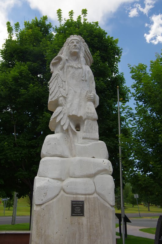
closed. We did manage to see a statue of
Chief Pocatello, and read some interesting details about him and the city. We're always commenting on how there's a
Southampton everywhere, and other towns and cites have multiple namesakes. There are however, no other Pocatello's in
the whole world!
and an interesting view of sun lit sagebrush. :
We stayed in three different places in Idaho. The first two were at reservoirs where we had water views and saw beautiful sunsets. Devil Creek Reservoir was just a one night stop before Pocatello. This is a picture of the sunlit mountain at the end of the reservoir.
We'd planned the stop in Pocatello to run some errands. I had a check to deposit and the bank wouldn't accept the check via the mobile app because the check was misprinted and the corner of the check border was missing. Our mail forwarding service in Florida had another check for us, so we had to pick a place to have the forwarding service send us our mail. We chose Pocatello because it was on our route and they had a Bank of Some of America (Jim's nickname because they aren't in quite a few states).
We parked the motorhome at a Lowe's in Pocatello, unhooked and headed for the post office and bank. After running our errands, having lunch, and stopping at a grocery store, we went back to the coach, hitched up and headed 30 miles to American Falls, where there are no falls but there is a dam and a large lake. There were falls, but they disappeared when they built a dam in 1926. During the process of building the dam, the original town was also moved: In all 344 residents, 46 businesses, three hotels, one school, five churches, one hospital, six grain elevators, and one flour mill.
Re Chief Pocatallo, he was a well loved chief of the Shoshone. when he died he was buried with his 18
horses (owning horses was a sign of wealth), under the American Falls. He is
now somewhere under the reservoir where we camped for 3 nights!
Our stay at American Falls provided us with some more spectacular sunsets over the water,
For more pictures of Idaho, click here: Idaho
Saturday, June 15, 2013
Of Moths and Mice
One day, several days
after leaving Antelope Island, we were sitting outside enjoying the pleasant
70ish temperature when Jim heard water dripping. Turning around we noticed a large wet spot
underneath the coach. Emptying out the
small storage bay we noticed water several inches deep, and on the other side
of the coach, in the wet bay (where the fresh water comes in), there was a lot
more water. Knowing that after mice
ingest the bait poison they seek water, we were concerned that a mouse might
have chewed his way into a hose, or worse yet, our water tank. We spent the next hour or so mopping up water
and drying things out, but thankfully saw no signs of mice. Jim thought perhaps the hose fitting hadn't
been tight enough and that the campground's strong water pressure was causing
the fitting to leak. He resolved the
problem by putting a regulator on the hose connector and since then there have
been no signs of water leaks. It's a
good thing the weather was nice that day and we were sitting outside. And it wasn't too hot or too cold to be
mopping up water!
Thursday, June 13, 2013
Antelope Island
Who knew there was an island in the Great Salt Lake that was
a state park with RV sites? We stumbled
upon this information while researching where to stop between Moab, UT and
Pocatello, ID (more on that later). Despite warnings that biting gnats were fierce
on the island, we decided to take our chances.
Antelope Island is connected to the mainland by a 8 mile
long causeway. Our first views, as we approached the island, were of small mountains peeking through fog.
The campground is on terraced sloping terrain and the campsites are far apart, all with great views of the hills and the lake, which has other island mountains in it.
Here's a picture of our campsite and our view.
Below is a view from the visitor center.

Antelopes and bison roam freely over the island, and there are lots of birds, as well.
The campground is on terraced sloping terrain and the campsites are far apart, all with great views of the hills and the lake, which has other island mountains in it.
Here's a picture of our campsite and our view.
Below is a view from the visitor center.

Antelopes and bison roam freely over the island, and there are lots of birds, as well.
The island is 18 miles by about 2 miles, all owned by the state park. At the southern end is the Fielding Garr ranch, now owned by the state and operated as a free museum. Previously it was owned by a succession of private owners, as well as the Mormon Church and several large companies.
We enjoyed an afternoon wandering through the old buildings at the ranch, and Jim practiced roping skills.
We also enjoyed some spectacular sunsets over the lake
as well as some interesting storm clouds.
We had prepared for the gnats with face masks and head nets, but after 2 days of gnats, mosquitoes and giant moths, we gave in and left.
For more pictures of the views and fabulous sunsets, click Antelope Island
Subscribe to:
Posts (Atom)