Saturday, May 18, 2013

Pikes Peak Everywhere

From the first sight of Pikes Peak we were in awe.  America's mountain, over 14000 feet high, where a young woman was inspired to write "America the Beautiful" looms over the Colorado Springs area, offering magnificent views wherever you go.  And the appearance of the mountain changes with day, time, and weather.

Here are just a few of the views of the mountain.
 
Later -- our trip up to the summit.


From Falcon Meadows Campground

 
From our rig on a  rainy afternoon during the RVSEF conference.


From our rig on a  clear morning during the RVSEF conference.


From a highway


From Manitou Springs -- afternoon clouds coming in

 
From Garden of the Gods - Afternoon


From Red Rock Canyon Trail -- Evening

Wednesday, May 15, 2013

The Monuments of the High Plains

A 200 mile drive west took us to Oakley, Kansas, our next stop.  At some point we were now on the High Plains -- mostly flat land where we could see for miles, going gradually up.  By the time we reached Oakley the altitude was 3000 feet. 


We checked in to our home for the night, chatted with the owners for awhile, parked, unhitched, and jumped into the Subaru for a 30 mile drive to Monument Rocks.  
After getting off the main road we had to travel about 7 miles on a dirt road -- but we remembered that this was one of the reasons we bought an all-wheel drive Subaru. 


Enough with the car commercial. 


Monument Rocks are chalk formations that reach a height of up to 70 feet, and they are sometimes referred to as the Chalk Pyramids.  They were formed 80 million years ago and include a variety of buttes and arches.  They are one of the 8 Wonders of Kansas.  (We haven't yet discovered what the other 7 are.) 


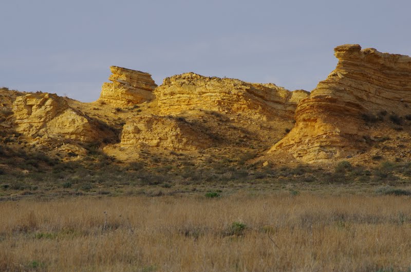
Across the road from the Chalk Pyramids are some smaller buttes that are orange/gold in color and when the sun shines is a particular in a particular way they sparkle.  These formations are behind a barbed wire fence on private property, so we could only view them from the road.  But they certainly glowed as the sun was going down!


We headed back to the RV Park, stopping to take pictures of a bigger-than-life sculpture of Buffalo Bill Cody killing a buffalo.  If you're wondering why this is in Kansas:  this is where Bill Cody won his nickname in a buffalo shooting contest held in the town of Oakley.  The competition was between Cody and William Comstock,  two buffalo hunters.  Bill Cody brought down more buffalo so he officially became known as "Buffalo Bill". 


For more pictures of our most recent travel in Kansas, click Kansas - Great Plains.

Monday, May 13, 2013

Mile High Chips

Colorado Springs, May 13th, 2013
Altitude > 6000 feet
 
Are they chips or balloons?  It seems that the bags of chips we brought from home, packaged on the east coast at sea level, have expanded due to the altitude.  We can now have a catch with them without damaging the chips. I just hope they don't explode in the cabinet before we open them. 


Also of concern is a bag of basmati rice packaged in San Francisco, that has filled up with air. 


Maybe this is actually a good thing, for the chips
anyway -- they might be better protected with the excess air as they rattle around on their ride along the highway.  And they might stay fresher. 


On the other hand, the rice might do better in a Ziploc bag.  Maybe I'll do just that -- double bag the rice so if the bag does explode I won't have rice all over the cabinet.


Friday, May 10, 2013

Middle Kansas Rocks


As we continued our westward journey across Kansas from Clinton State Park we were extremely surprised at the terrain.  We had always envisioned Kansas as being flat and brown.  This was not the case, at least in this part of Kansas.  We saw a sign announcing Flint Hills -- it sounded like a nice name for a residential community.  We were going up and down and up and down, surrounded by beautiful open green fields.  We later learned that Flint Hills was the name of the hills we were travelling through, and not a housing development.  In fact, there were no housing developments -- just open farm land for miles on end.

We arrived at the Salina, Kansas KOA around 3 o'clock and headed out to Mushroom Rocks State Park.   This is a very small park -- only about 5 acres (compared to the 1500 acres of Clinton State Park where we stayed last night).  Neither of our two gps devices knew anything about this park.  This was something we'd picked out of the book "Off the Beaten Path", so we weren't too surprised.  We could have used the smart phone,  or asked in the campground office,  but I looked at a map and saw that Mushroom Rock State Park was near Kanopolis State Park, which the GPS could find.   I hoped that somewhere along the way the State of Kansas would have posted a sign directing us the right way.  And they had. 


We explored the mushroom shaped rocks here for about 30 minutes, then took off back to the campground to pick up the spare camera battery which I'd left in the coach.  (My battery was about to die.) 


Our next destination was Rock City.  The gps knew this one.  And we knew there'd be signs because we'd seen signs for it on the interstate.  It's a commercial property -- they ask for a $3 donation, so we didn't know what to expect.  We were once again, surprised by the terrain and the scenery.  Off the interstate we were on a state highway that took us north towards Minneapolis -- not MN, Minneapolis, Kansas.  We turned onto a dirt road at a beautiful field of golden flowers and went up a hill. 


There was sign and a little stone cabin (perhaps a former pioneer hut) where you could deposit your $3 fee. 


And in a field, there were these huge rocks, mostly dome shaped and mostly climbable.  While Jim paid the fee I watched as a little boy of about 5 scampered over the rocks,  What fun he was having! 


We explored the area, and did some climbing, and looked out over the valley. 


It was a beautiful day with blue skies and fluffy white clouds, and not even a breeze. So far Kansas has been good to us.
 
For more pictures of our travels through Kansas see Kansas
 
and stay tuned for the next post:  the Monuments of the High Plains.   


Thursday, May 9, 2013

Rolling Hills in Eastern Kansas


Clinton State Park in Lawrence, Kansas is just east of Kansas City.  And like most big cities, Kansas City at rush hour is multiple lanes of traffic not moving.  We were on the I270 loop around the city, but at rush hour people certainly weren't getting anywhere in a rush.

Our debate:  get off at KS10 and drive for 28 miles on an state road, 26 miles of which, according to our GPS device, were under construction, or, drive 16 extra miles in the horrible rush hour traffic to get back on I70, just to get off again in a few miles.  Jim opted to take KS10, and he made a good choice.  There was little construction and not much traffic on this parkway like road,  and the scenery was fabulous -- lots rolling green hills until we got into the town of Lawrence, where it got a little more suburban with stores and apartment buildings.    

We made our way to Clinton State Park, where we picked our favorite site and set up.
 
 
The park is 1500 acres of the same kind of rolling hills.  Behind the motorhome is a huge field   
 
 
and the nearest RV appears tiny in the distance.

 
We explored the park and it's rolling green hills and took a trail down to the shore of Lake Clinton.


 We enjoyed the park for another day and also spent some time exploring Lawrence, before heading out to our next stop.
 
Stay tuned for more on Kansas ...


Wednesday, May 8, 2013

The ABC's of Missouri

As we travelled across Missouri on Interstate 270 and 70, watching the scenery go by,


we noticed something a little odd.  Many of the signs for intersecting roads were single letters, (e.g. A, H, W)

 
or, sometimes double letters (e.g. KK, YY).


Jim speculated that since the first interstate project was in St. Charles, MO, perhaps back then they decided to name the cross streets alphabetically.  When they ran out of letters they doubled up, but soon they ran out of even the double letters.  We don't know -- this was just idle conversation. 


Tuesday, May 7, 2013

We Walked across the Mississippi, on Route 66


No kidding!

After another day of driving, we stopped for the night in Granite City, IL, just across the Mississippi from St. Louis MO. 

I'd like to shout out a thank-you to the friendly UPS driver who helped us with directions to our campground.  We stopped for fuel 3 exits (3 miles) before we had to get off for the campground.  Just as we were getting off I270, the traffic ahead was at a standstill (about 4:15 PM).  We knew getting back on the interstate would be a mistake.  We asked in the travel center store, but the girl didn't seem so sure of her directions.  When I spotted a UPS truck in the parking lot, I walked over and asked the driver for help.  He gave us directions "the back way", as I hoped he would, and we were able to travel the 3 miles in short time.

After setting up our home for the night,  we took off for the Old Chain of Rocks Bridge, built in 1929, which used to take cars travelling on Route 66 across the Mississippi.   

Today, the bridge is preserved as a biking and walking trail. 


You have wonderful views of the river,
(this one's of the flooded shoreline area):


the I270 bridge,

downtown St Louis, including the arch
 
 
and adorable gothic style water inlets for the city of St. Louis. 

 
And we were lucky enough to have a great sunset. 


The bridge is a fascinating structure of geometric shapes. 
 
 
For more pictures of the Old Chain of Rocks Bridge, and our further travel across Missouri, click Missouri